The earthquake struck
A royal palace shook terribly
Now it’s a ruin

The earthquake struck
A royal palace shook terribly
Now it’s a ruin
VASCO DA GAMA and his Portuguese crew set foot on Indian soil near Calicut in Kerala in 1498. The Portuguese were not the first Europeans to arrive in India: Romans had traded with India long before the fifteenth century, but there are no known remains of any structures they might have built. Despite the lack of any structures known to have been built by the Ancient Romans, many Roman coins have been found in India.
In 1503, five years after Vasco arrived, some Portuguese sailors erected a wooden fortress at Pallipuram, about 18 miles north of the present Fort Kochi and 100 miles south of Calicut. Two years later this fort was replaced by a hexagonal stone structure. This two-storey edifice is believed to be India’s oldest existing building built by Europeans.
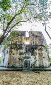
The upper storey of the fort, on which would have been placed canons, no longer exists. Each of the fort’s six walls are about 6 feet thick, 32 feet wide, and 34 feet tall. They contain 18 former embrasures for cannon.
A staircase leads from the ground to the ground floor of the fort. Next to this, there is a circular plaque with the words: “Pallipuram Fort. The most ancient European building in India. About 1503. Conserved as a historic relic by the Government of Travancore. AD 1909”.
The fort remained in Portuguese hands until 1661, when it was captured by the Dutch. Then the Dutch sold it to the Kingdom of Travancore in 1789. It remained under the control of Travancore until India became independent in 1947.
Today, although little remains to be seen apart from the hexagonal walls, it is fascinatingly evocative to visit a place with such an interesting history. Located within its peaceful grounds there is a square pond (tank) filled with water. I have no idea how long that water feature has been in existence.
Standing looking it in the hot humid heat on a January afternoon, I wondered how the sixteenth century Portuguese managed to bear the uncomfortable climate and survive in this fort that was once surrounded by steamy jungle.
“IT’S THE TOWN’S SYMBOL, you see”, we were told by a friendly young man whom we met by chance in a churchyard in the town of Bruton in the county of Somerset.
“Never been up there myself, even though I’ve been living in Bruton all my life,” he told us, pointing at a tall tower on the summit of a hill overlooking the town.
“Where have you come from?” he asked us. When we replied ‘London’, he commented:
“Never been there myself. Have a good evening.”
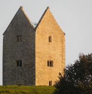
Bruton is about 120 miles southwest of central London. The tower about which we had asked the young man is square in plan, is built of neatly cut limestone blocks, has three layers of windows, and looks (from below) as if it is missing its roof. The top parts of each of the four walls are triangular, looking as if they were once the side walls of gabled roofs.
The tower that stands in Bruton’s Jubilee Park is known as ‘The Dovecote’. The hill on which it stands rises steeply from the almost level fields of the public park. Birds, mainly pigeons, could be seen perching on the edges of the four gables at the top of the tower. It stands on a square plot 65 square feet in area and is situated on land over 300 feet above sea level, to the south of the centre of Bruton. Although it is tall, I have not been able to discover its height by searching the internet. That it has lost its roof, is recorded.
The tower stands in what was a deer park of about 30 acres established in about 1545-6 by the canons of the long-since demolished nearby Bruton Abbey (whose remains can be seen in the town). The park was later enlarged and surrounded by a wall. In the 18th century, the deer were removed. However, much earlier, in the 16th or, 17th century (actual date is uncertain although some of the timber used in the construction has been dated as being felled between 1554 and 1586), the present tower was built by the Berkly family. They acquired the land after the Dissolution of the Monasteries by Henry VIII. The tower was built to be used as a ‘prospect’ or ‘look out’ tower.
In about 1780, or maybe much earlier, the tower was converted to be used as a dovecote. Inside the tower, which we could not enter, there are roosting spaces (nesting boxes) for at least 200 doves. Long ago, pigeons and doves were an important food source. They were reared for their eggs, flesh, and dung. In 1915, the National Trust (‘NT’) acquired the freehold of the tower from Sir Henry Hugh Arthur Hoare (1865-1947). Not only did Sir Henry give his tower to the NT, but also, more importantly, he also donated his family estate with its fabulous landscaped grounds at nearby Stourhead to the same organization in 1946. The Hoare family, about whom I hope to write soon, is also associated with another tower not far from Bruton, the Alfred Tower, which we have visited … but more on this anon.
Although we could not enter The Dovecote tower, we did one better than the young local with whom we spoke earlier; we walked up to its base.
OUR GOOD FRIENDS IN HERTFORDSHIRE always take us out into the countryside for a walk with their two friendly dogs. Invariably, we visit countryside that is both beautiful and contains something of interest. This time, we parked in the small hamlet of Thundridge (in Hertfordshire), which is located on what was once the Roman road, Ermine Street (from the Old English ‘Earninga Straete’). This thoroughfare linked London with York. We set off by walking along a small road named Old Church Lane. This soon becomes a footpath that runs alongside the River Rib, a tributary of the River Lea, which in turn is a tributary of the River Thames. The Rib merges with the Lea in the town of Hertford.
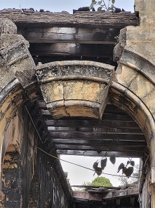
We walked past a vast field in which some grassy crop was growing. Far across the field there was a small wood. A church tower could be seen rising from amongst the trees. We followed another path towards the clump of trees and soon arrived at the tower. This tower and a graveyard is all that remains of the church of St Mary and All Saints (some call it ‘All Hallows and Little St. Mary’ and others ‘Thundridge Old Church’), which was demolished (apart from the tower) in 1853, when a new church was built in Wadesmill. The tower was constructed of flint and mortar in the 15th century. The rest of the church, now demolished, was built in the 11th to 12th centuries. A Romanesque archway now set into the eastern wall of the tower is the only visible remains of that former church. Although this ruined tower might well appeal to those who find ruins romantic, it is in a bad condition with some of the structure covered with corrugated iron sheeting and other parts with graffiti. There are some plans to conserve it and others to demolish it to make room for new housing.
The reason that the old church was demolished was that the old manor house, which was close to the old church, was demolished in the 19th century. Consequently, the population of Thundridge moved nearer to the new manor house that was built where the church built in 1853 now stands.
Just before we reached the old church tower, we passed a field which had a long grass-covered trench running along it. This is the remains of a moat built long ago when Thundridge village was located near to the the old, now demolished church. The banks of the moat were liberally studded with mole hills. This moat is believed to have been dug in mediaeval times. What remains of it is ‘D’ shaped and encloses an area bounded by sides of approximately 660 feet north to south and by the same east to west. The moat enclosed the site of the former manor house.
Having seen all that remains of Thudridge Old Church, we retraced our steps to Ermine Street, crossed the fast-flowing River Rib, and then ate an enormous roast lunch in the garden of the nearby Feathers pub in Wadesmill, which is about two minutes’ walk from Thundridge.
