
w
Sailing serenely
Along the city’s old canal
A pleasant life

w
Sailing serenely
Along the city’s old canal
A pleasant life
EVERY FEW WEEKS, we walk along the towpath of the Grand Union Canal (Paddington Arm) between the Meanwhile Garden in North Kensington and Little Venice near Paddington station. About 1/3 of the way along this route, we stop at the pleasant Grand Junction Café. Many canal narrow boats are moored alongside the towpath. Most of them are floating residences. Today, 31 August 2025, we spotted a narrow boat that we had not seen before. Moored between the Meanwhile Garden and the café, it is a floating, mobile art gallery.

Below the words “Canal Boat Contemporary” attached to the starboard side of the boat, there was a large glass-covered frame facing the towpath. This contained about 15 paintings. Next to the frame, there were notices giving information about the gallery’s concept and the works of the artist being displayed. There was also a whiteboard on which viewers could add their reactions to the art, using the marker pen attached to it. Between 27 August and 2 September, works by the artist Henrietta Roeder are on display.
Also attached to the boat and visible to passersby was the ‘manifesto’ of Canal Boat Contemporary, which can be read on a website (www.canalboatcontemporary.com). It refers to the ‘box’, by which they mean the display containing the art. Here are some excerpts from the manifesto to illustrate what the organisation is trying to achieve:
“Opera sings to chandeliers. If art wants to matter, it has to leave the palace … We moor up. We don’t ask for permission.We resist fixed power structures and take art to different places and contexts … We’re all speaking, nodding, showing – but always to each other. The Box is a window turned outward – away from the art world – for new eyes. It’s for someone walking their dog … The Box is modest, but powerful. A single painting on the towpath can shake you to the core … We don’t want your submissions. We want doppelgängers. Copy us. This idea wants to spread like moss. All you need is a frame no one’s using. A window everyone passes.”
Seeing the boat with its artworks, appearing as if from ‘out of the blue’ was a lovely experience. I think it is a wonderful idea to bring contemporary art outside of great institutions and commercial art galleries to make it available for anyone to stumble across unexpectedly.

See the canal
Enjoy the birds and many boats
Savour London’s sights

Gently floating
In a gondola seat-ed
Tourists are so happy
I HAVE LEARNED a new word today. It can be used as both a noun and as a verb. The noun is ‘gongoozler’ and the verb is ‘to gongoozle’. I came across it used as a verb on an information panel by the south side of the water basin at Paddington’s Little Venice, where the Paddington Arm of the Grand Union Canal enlarges to become a pond, from which the Regents Canal commences.

The word gongoozle might possibly derive from two words of Lincolnshire dialect: ‘gawn’ and ‘gooze’. Both these words mean to stare or gape. A ‘gawn’ can also mean a small freight-carrying boat such as a canal narrowboat.
Gongoozling usually refers to watching boats. And this is what we did today as we ambled lazily along the Paddington Arm and the shore of Little Venice. With the sun shining and a pleasant air temperature (about 21 degrees Celsius), this was an enjoyable way of passing time on a Sunday morning.
WIGAN PIER WAS made famous by the author George Orwell, who published his “The Road to Wigan Pier” in 1936. Recently, we were staying in Widnes (Cheshire), which is not far from Wigan, a town that was in Lancashire when Orwell wrote his book. So, we decided to see Wigan Pier for ourselves.

A quick glance at a map reveals that Wigan is not on the sea, which is where most piers are to be found. The town is inland, and the so-called Wigan Pier is neither a pier nor on the seaside. It is on a part of the Leeds and Liverpool Canal in central Wigan. It was originally a landing stage where locally mined coal was loaded onto barges.
The name ‘Wigan Pier’ might have originated when a train carrying excursioners to the seaside was delayed at Wigan and they saw a structure that looked like a pier, as the following (from http://www.wiganarchsoc.co.uk/content/Projects/WiganPier.htm#Folklore ) described:
“…not long after leaving Wallgate Station, an excursion train from Wigan to Southport, was delayed on the outskirts of Wigan and passengers saw a long wooden structure that reminded them of Southport Pier. This structure would have been the 1,050 yard long wooden gantry … It was built in the late 1880s and carried a double line of rails from Lamb and Moore’s Newtown Colliery high across the River Douglas, the canal and the Wigan to Southport Railway line, to Meadows Colliery by Frog Lane … It certainly would have been easy to see this wooden gantry from a train heading towards Southport.”
I cannot say whether or not this is the true origin of the name, but it is a good story.
We took a road to Wigan Pier and after going around the town’s one-way system and several roundabouts, passing a huge Asda store a couple of times, we arrived at a series of old warehouses labelled Wigan Pier, and parked next to the canal. The Orwell visitor centre, which we were led to believe existed, is no more. A passer-by, with whom we chatted, told us that any memorials to Orwell and his book had disappeared a few years ago. Likewise, the collieries: these have been closed down long ago. Where they were there are housing estates, factories, and shops.
The warehouses close to where the coal used to be loaded many years ago, were inaccessible. They are being redeveloped to create a leisure ‘hub’. This will include (according to hoardings surrounding the old buildings): a beer tap house; conferences; live music; canal tours; festivals; a food hall; and an ‘artisan deli’. I am not sure what is meant by an artisan deli, but whatever it is, I am sure that should George Orwell ever make his way back along the road to Wigan Pier, he would be truly astonished by it.
SPIRAL RAMPS LEAD up to the Ha’penny Bridge, which allows pedestrians to cross the Paddington Arm of the Grand Union Canal, where it runs between Delamere Terrace on one bank and Blomfield Road on the opposite one. A few yards west of the bridge and south of the waterway, there is a Victorian gothic church with a tall tower decorated with layers of red brickwork separated by layers of white masonry and topped with a white spire. It is St Mary Magdalene’s church.

The church was designed by George Edmund Street (1824-1881) and completed in 1878. It was built in what was then an area with poor quality housing, where several hard-up families lived crowded together under one roof. The parish in which it is located began life as an offshoot of All Saints in Margaret Street (near Oxford Circus). Like All Saints, St Mary Magdalene’s was established as an Anglo-Catholic church. Its website, grandjunction.org.uk, revealed that Anglo-Catholicism:
“… emphasises the Catholic heritage and identity of the Church of England. In the mid-nineteenth century Anglo-Catholicism was very controversial and provoked riots. Anglo-Catholic churches were often built in very poor areas, and their clergy believed that their services, full of light, colour, music and ritual, were likely to appeal to the poor.”
Like All Saints Margaret Street, the interior of St Mary Magdalene’s is a masterpiece of Victorian gothic extravaganza, a riot of colour. The nave has a magnificent painted ceiling which includes faces of various saints. This was painted by Daniel Bell, a Victorian artist. Sculptures of saints carved by Thomas Earp (1823-1893) look down on the nave. The floor of the vast nave is decoratively tiled. Street did not believe in fixed pews such as are found in many other Victorian churches and were rented out to parishioners to raise money. He believed in ‘free seating’, especially in a church like St Mary Magdelene’s that was built to serve the poor. The apse is unusual in that it is polygonal, reminiscent of apses that the widely travelled Street had seen in French and Flemish churches.
An unusual feature of this out of the ordinary church is that although the nave is flanked by a south and a north aisle, the latter is barely wide enough to accommodate one person, whereas the south one is almost as wide as the nave. The reason for the narrow north aisle was related to building regulations in force when the church was being constructed.
If it is open, and it was when I visited the church, it is worth entering the undercroft. This area beneath the church is flanked on its south side by a chapel that was undergoing restoration in February 2022. This is the chapel of the Holy Sepulchre created to commemorate the church’s founder and first vicar Fr Richard Temple West (1827-1893). Containing much decorative artwork and resembling a mediaeval chantry chapel, it was created by the architect Ninian Comper (1864-1960).
Outside the church, there is a WW1 memorial, added by Martin Travers in 1929. It is a gold-coloured crucifixion with a stone base on which are inscribed the Latin words “Infinitum est”, which is neither classical nor biblical; it means ‘It is not finished’, which are ominous words on a war memorial and are most portentous on a memorial to the first of (so far) two world wars.
Added on to the west end of the church, there is a modern extension, which houses a pleasant refreshment outlet called the Grand Junction Café. This is a good place to rest for a while after the excitement of seeing inside the spectacular church.
NEEDING BREAKFAST ON our way from Warwick to visit Baddesley Clinton House, we chose to stop at the Hatton Locks Café, which we had noticed on our road map. What we did not know is that the café is located next to the uppermost of a flight (or series) of 21 canal locks. The locks are situated on a stretch of the Grand Union Canal that was, when it opened in 1799, the Warwick and Birmingham Canal, which was built to carry locally mined coal for use in power stations and nearby factories (https://canalrivertrust.org.uk/enjoy-the-waterways/canal-history/history-features-and-articles/the-history-of-hatton-locks). It became an important transportation link between London and The Midlands.

The 21 locks are spread along an almost 2 mile stretch of the canal and the towpath along this section of the waterway is popular with cyclists, walkers, and their dogs. Some of the locks are narrow. They were built when the canal was first constructed. Other locks on the flight are far wider. They were built in 1932 and allow two craft to use the lock simultaneously. The newer locks were built at a time when the canal system began to have to compete with motorised road and rail transport.
The café is about 310 yards northwest of a small car park and is reached by walking along the towpath. Near the café, there are some unusual looking tables and benches made of old timber. Most of the timber pieces are planks with a short semi-circular projection at one end. These wooden piles used to be driven into the floor of the canal between parallel wooden blocks that held them straight upright against the walls of the waterway. Their purpose was to prevent the banks of the canal from being eroded by the water flowing past them. Nowadays, they have been replaced by coir matting that serves the same purpose because it is considered to be more eco-friendly that timber. The wooden piles were driven into place by a mechanised hammer system aboard a motorised boat that plied along the canal. One of these boats, now disused, has been preserved near the café.
The locks on the Hatton Flight looked different from the many other canal locks we have seen on our travels around the country. Each lock is flanked by what looks like a pair of tall, stout candles. These things house the mechanisms that control the flow of water into the locks and are operated by canal users equipped with a special handle or windlass that fits onto a projection that is linked to the gearing that operates the valve.
The Hatton Locks Café is a real treat, both visually and gastronomically. Both inside and outside, it is decorated with a profusion of objects, some folkloric, some whimsical, and others related to the life and traditions on the canal. A team of friendly workers produce simple but excellently prepared English breakfast items as well as very acceptable coffees. So good was our breakfast that we made a detour to return to this place on the following morning. Most of the clientele seemed to be locals, many of whom were on friendly terms with the staff. Although we had only been once before on a busy morning, the staff remembered exactly what we ate and drank on the day before. When we are next nearby, we shall certainly visit this wonderful establishment again. On our next visit, we will join the other walkers and stroll past all the 21 locks.
PARKWAY LEADS GENTLY uphill from Camden Town Underground station to a short road called Gloucester Gate, which leads to the Outer Circle that runs around Regents Park. Much of Gloucester Terrace runs along what looks like a bridge, which is lined on its north side by red-coloured, decorative stone parapet.

The bridge traverses a grassy dell that does not appear to contain any kind of watercourse. I wondered why such an elaborate bridge had been built to traverse what appears to be merely a grassy hollow. Well, when it was built, it did cross a waterway, the Cumberland Market Branch of the Regent’s Canal known as ‘The Cumberland Arm’ (www.londonslostrivers.com/cumberland-arm.html). This waterway, built in 1816, ran for about half a mile from the Regents Canal to a basin near Euston Station, running for most of its length parallel to Albany Street. During WW2, the Cumberland Arm, which had up until then been used to transport freight, was used to supply water to firefighting appliances. By the end of the war, the canal had been filled with rubble from buildings destroyed by bombing and then covered with topsoil. All that remains of the Cumberland Arm is a short blind-ending stretch of water near Regents Park Road, on which there is a large floating Chinese restaurant and a few moorings for narrow boats.
The Gloucester Gate bridge with its decorative parapet and elaborate cast-iron lampstands also includes two interesting memorials. One of these relates to the fact that the bridge was constructed by the St Pancras Vestry, the then local authority governing the area (www.andrewwhitehead.net/blog/the-most-pointless-bridge-in-london). There is a bronze bas-relief depicting the martyrdom of St Pancras. It was a gift of William Thornton and sculpted by the Italian Ceccardo Egidio Fucigna (c1836-1884), who died in London. St Pancras (c289-303/4) was born a Roman citizen. He converted to Christianity and was beheaded for his beliefs when he was 14 years old (https://en.wikipedia.org/wiki/Pancras_of_Rome). The bronze relief on Gloucester Gate bridge shows a young man being mauled by an animal, possibly a lion. Why this motif was chosen when the saint was beheaded puzzles me.
Near the St Pancras panel, also on the bridge, there is an old but elaborate drinking fountain. A metal plate attached to it has faded letters that read:
“Saint Pancras Middlesex.
This fountain and works connected therewith were presented to the Metropolitan Drinking Fountain Association on the (?) day of August 1878 by
Matilda
Richard Kent esq. Junior Churchwarden 1878.
The figure … cast in bronze was designed by Joseph Durham ARA.” (https://victorianweb.org/sculpture/durham/1c.html)
The fountain, known as ‘The Matilda Fountain’, is part of a miniature cave made with granite boulders. A sculpture of a milkmaid stands above the cave. At her feet, there is a wooden pail with two handles. The girl with a rich crop of hair on her head is depicted shielding her eyes from the sun with her right hand as she stares into the distance. Cast in bronze, the female figure and the pail were sculpted by Joseph Durham (1814-1877). Matilda might possibly have been Richard Kent’s wife, but the plaque does not specify this. The sculpture is not unique; several other copies of it, all by Durham, exist. One of these, dated 1867 and called “At the Spring/Early Morn”, can be seen in Blackburn’s Town Hall (https://victorianweb.org/sculpture/durham/1d.html).
Today, the bridge is redundant since the canal was filled-in long ago. However, it is used by many people walking to and from Regents Park and its zoo and a steady stream of vehicular traffic crosses it. Although it has outlived its original purpose, the bridge serves as a reminder of a once important element of London’s continuously evolving transportation system.
EVERY NOW AND THEN, a canal needs repairing. For example, it might have sprung a leak either in its retaining walls or in its clay bottom. In such circumstances and no doubt others, the repair work can only be carried out if the canal is emptied of water, a tall order in a canal that might be many miles in length. Recently, we were walking along the towpath of the Macclesfield Canal, which links Marples Lock on the Peak Forest Canal with Hardings Wood Junction on the Trent and Mersey Canal, when we spotted something that we had never noticed before whilst walking along a canal towpath.
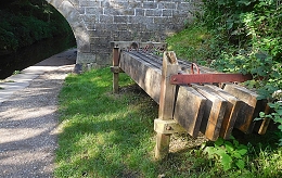
What we saw was a pile of sturdy wooden planks, each with two metal handles attached to their narrowest edges. They looked quite modern. We asked a man, who was walking his dog, about the planks. He explained that they were used to block both ends of a section of canal between two consecutive bridges. When these barricades are lined with plastic sheeting, the water between the two barricades can be drained from the part of the canal between the two waterproofed wooden barriers, Then, work can be carried out on the drained stretch of the canal. The planks are known as ‘stop planks’
Our informant pointed out notches carved in the stonework near to a bridge. The notch is opposite another identical one across the canal. It is into these pairs of notches that the planks we had noticed ate inserted to create a dam, I regard myself as being quite observant, but I have never seen or noticed either this kind of notch or the wooden planks for inserting in them during many long walks along canals in other parts of England. Maybe, they are common, but until we walked beside the Macclesfield Canal, I had never seen them before, Maybe, this is because other methods of damming (see: https://www.rchs.org.uk/wp-content/uploads/2017/01/OP-128.pdf) are also employed in addition to that which we spotted on the Macclesfield Canal at Bollington in Cheshire.
