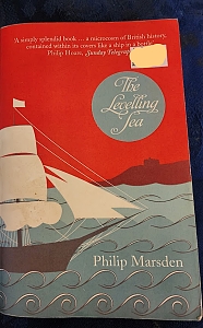
I HAVE JUST finished reading “The Levelling Sea” by Philip Marsden. By describing many aspects of the history of the town of Falmouth in Cornwall, he not only brings the town’s colourful and important past to life but also gently introduces the reader to many facets of English maritime history.
I have visited Falmouth many times. This book makes sense of many things I have seen there. It has also introduced me to many features of the town, past and present, that I had not known about. Likewise, it has enlightened me on aspects of English maritime history that were new to me.
The book is well-researched, yet is not stolidly scholarly. “The Levelling Sea” is beautifully written. Although not poetry, its prose feels almost poetical.
I HAD NEVER HEARD of the artist Anna Boghiguian (born 1946) until we visited her exhibition at the Turner Contemporary Gallery in Margate (Kent). Anna was born in Cairo (Egypt), where she studied political and social sciences at The American University. She also studied fine arts and music at Concordia University in Montreal (Canada). The works on display at Margate until 26 October 2025 are a superb synthesis of both her interests in world affairs and artistic talents.
Anna’s show at the Turner is called “The Sunken Boat: A glimpse into past histories”. It consists of three installations, one in each of three spacious galleries. One gallery contains an installation comprising a set of sandy beaches littered with the remains of wrecked boats and sails along with other flotsam and jetsam. The walls of the room have frames containing images relating to historical and ecological events. Regarding this fascinating and beautifully composed exhibit, the gallery’s website noted that the installation:
“… the centrality of the sea in shaping histories of labour, trade, ecological collapse, and political conflict. It combines sculpture, painting, cut-out figures and sound, inviting reflection on rising sea levels and geopolitical tensions around undersea communication cables.”
Another room has a cluster of cut-outs depicting famous people of the past including Einstein, Gandhi, Queen Victoria, Napoleon, Pythagoras, and many others. Each of the cut-outs are colourfully painted and are suspended from the ceiling by fine threads, and hang above a large black and white chess board. They rotate gently in reaction to movements of the air caused by motions of the viewers.
The third gallery contained an installation that evoked being under the sea. Figures either swimming or drowning are suspended from the high ceiling. The room is lit with a blueish glow that gives the viewer the feeling of being below the sea’s surface. The floor of the gallery is a representation of the seabed, with undersea cables, marine creatures and plants, assorted debris, and other objects one might expect to find there. The lighting was chosen to evoke the reduced illumination that one can imagine exists deep below the sea’s surface. It reminded me a little of the church at Tudely (Kent) whose stained-glass windows by Chagall create the same impression. In this church, Chagall designed the windows to create the impression of being below the sea because the edifice is dedicated to the memory of someone who died by drowning. Unlike the church at Tudely, the installation at the Turner expresses a less specific, more global concern: that of the sea’s ecology at present and in the future.
Words can hardly do justice to the amazing show at Margate. Without doubt, it must be seen to be fully appreciated. The exhibition illustrates that Anna Boghiguian is a competent and imaginative artist with a great grasp of past and contemporary political and present ecological challenges facing the waters in our seas and oceans. And she knows how to express these matters in imaginative and compelling ways,
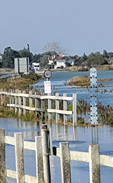
THE ISLAND OF MERSEA is connected to the mainland of Essex by a causeway, which was originally constructed before the medieval era. It is the only way that vehicles, motorised or otherwise, can travel between Mersea and the rest of Essex.
Twice a day, the tide rises. When it does, not only do the mudflats close to the island become submerged beneath the sea but also the causeway.
The flooded causeway
After visiting East Mersey, we drove to the causeway and had to stop in a long queue of traffic. It was high tide, and the water had not only covered the causeway but also about 200 yards of the roadway approaching it. It was interesting to see how even in the 21st century, a simple thing such as high tide can bring life to a standstill.
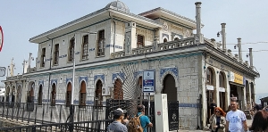
ONE OF ISTANBUL’S many attractions is that it is intimately associated with water: the Golden Horn, the Bosphorus, the Black Sea, and the Sea of Marmara. Incorporated within the city’s excellent public transport system, there are many boat services on all these bodies of water. During our recent visit to the city in April 2024, we took a boat from Kabataş on the European shore of the Bosphorus to Büyükada – one of the Princes Islands out in the Sea of Marmara. This pleasant journey took about 1 hour and 40 minutes. As we sailed across the smooth sea, flocks of seagulls followed us, and were fed by other passengers, who threw them bread and other titbits.
One of the piers at Büyükada has a beautiful old quay building in which passengers can wait for their boat and do a little shopping. Equipped with ticket windows, which are no longer in use because modern ticket machines have replaced them, the building is decorated with lovely tiling and stained-glass windows. As with many old buildings we saw in Istanbul, this one was supplied with a panel describing (in both Turkish and English) its history.
The pier was built in 1899. It was rebuilt with the addition of the present two-storey terminal building, which was completed in 1915 to the designs of its architect, Mihran Azaryan (1876-1952) from Izmit. He was an Ottoman Armenian. It is worthy of note that by the time that his building was built, the Ottoman rulers had been involved in the death of many Armenians.
The upper floor had a café between 1918 and 1923. And between 1950 and 1951, it had been the island’s first ever cinema. Between 2000 and 2001, the edifice was beautifully restored, and although the ticket windows no longer serve any purpose, its octagonal waiting room-cum-ticket hall is a rare survival.
Having seen this superb example of a ferry terminal, I kept my eyes open during the many other boat trips we made along, and across, the Bosphorus. Many of the landing stages have ornate terminal buildings – often with tiling and stained-glass windows, and sometimes with their names still in the old Turkish script. However, the terminal at Büyükada is the most impressive of all those we saw.
ONE OF THE MANY advantages of living close to central London is that it does not take long for us to reach the numerous commercial art galleries in Mayfair and Marylebone. Many of these hold exhibitions of modern and contemporary art, which is often fascinating to see. My mother was a sculptor, many of whose works were abstract rather than figurative. Being brought up in close proximity to someone so interested in the contemporary art world (of the 1960s and 1970s) might well have been a source of my lifelong interest in seeing works of contemporary artists (as well as modern artists who no longer live). My enthusiasm for viewing art has been enhanced by two people close to me. My wife has always had an interest in art in general and ‘modern art’ in particular. Our daughter, who works in the world of art and its propagation, has added to our enjoyment of experiencing artistic creations by recommending galleries with exhibitions that often prove to be most fascinating.
Recently, our daughter suggested that we see an exhibition, “As Above So Below”, by an artist with whom she is working. Creations of British born Tania Kovats (born 1966) are being displayed at an exhibition in a small Gallery, Parafin, in Woodstock Street (close to Bond Street Underground station) until the 24th of February 2024. Although she is known for her work in a wide range of artistic activities, she best known for her drawings and sculptures. The present exhibition includes many drawings and a few sculptural creations. The gallery’s ‘flyer’ (or handout) explained that:
“… Kovats’ enduring themes are the experience and understanding of landscape, geological processes, patterns of growth and the intersection of landscape, nature and culture and how art can speak to our critical climate crisis.”
This summarises what the artist is trying to convey with her artworks. Everything on display at the exhibition was pleasing visually and meticulously executed, but just by looking at the works I was unable to grasp anything about them but their beauty. Fortunately, the gallery’s flyer helps to explain the artist’s intentions.
Many of the works on display relate to the sea and evoke it beautifully. One exhibit, also connected with the sea, was a series of images of numbered, but un-named, graves of 20 migrants who lost their lives crossing the sea from Africa to the Italian island of Lampedusa. Near this artwork, there was another work – a line of used school shoes. This is Tania’s memorial to her son’s childhood, and (to quote the flyer):
“… explores how growth houses loss, and is built into the child’s progress towards individualisation.”
The passage of time is depicted in another work in the exhibition, “Luna”, in which a series of pictures depicting the phases of the moon as they change during a lunar month.
I am very pleased that our daughter recommended this exhibition by an artist, who we had not encountered before. Although I greatly enjoyed the exhibition, now that I write about it and reflect on what I saw and read, I feel that I would like to see the show once again because at a second viewing I will gain much more from it than during my first visit.
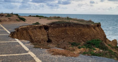
THE CAR PARK at Compton Bay on the south coast of the Isle of Wight is falling into the sea far below. The waves are undermining the cliff upon which the car park is situated. In conjunction with this, wind and rain are literally eating away the cliff. Where there had been a row of marked parking spaces, this has become unusable because the cliff has broken away. The markings are still visible, but they end abruptly at the fractured cliff edge. The local National Trust warden told us that next year, this disappearing car park will be closed and grassed over. A new one will have to be created further away from the clif edge. Seeing the damage being caused brought home how powerful are the forces of nature.
DURING THE 1890S, construction of new concrete naval structures commenced at Plymouth naval dockyard. The nearest source of gravel suitable for incorporating in concrete was in Start Bay on the south coast of Devon (just west of Dartmouth). Dredgers, which were able to suck up vast amounts of gravel from the seafloor, were sent to Start Bay. Every day, enormous amounts of gravel were removed from the Bay.
The remains of Hallsands are thr 2 houses closest to the sea
The inhabitants of the tiny fishing village of Hallsands, whose location was between Beesands and Start Point, noticed that as the gravel was being removed, the level of the sea was gradually lowering. This began to become serious because the gravel that was being removed in vast quantities had formerly protected the village (and others nearby) from being washed away by the action of the sea’s waves. When the authorities became aware of the damage being caused, gravel extraction was ended. But this was too late.
A huge storm in 1917 caused most of Hallsands to be washed into the sea, leaving only a couple of houses standing, albeing precariously. Had the gravel not been removed, the damage might have been considerably less, and more of the village might have survived.
Until recently, the precarious remains of Hallsands could be seen from a viewing platform high above the site. However, during the last year or two, further damage has made the path leading to the platform too dangerous to be used, and it has been fenced off.
Neighbouring coastal villages such as Beesands and Tor Cross, have also suffered damage from the sea because of the gravel extraction, but high thick concrete seawalls were constructed and barriers of huge rocks have been placed, and so far the villages’ integrity has been protected.
Old photographs show what Hallsands looked like before it disappeared. They reveal that its buildings resembled those still standing at Beesands. Whereas this village stands on level ground, the buildings in Hallsands used to line a steeply sloping main street that ran downhill to a small fishing harbour.
Although the tragic consequences of gravel extraction were predicted early enough, cessation of the removal of this protective material did not occur until it was far too late to prevent disaster. The villagers who lost their homes and livelihoods had to wait many years before they received any compensation.
Start Bay is a beautiful place to visit. Had our friends Tim and Christine not taken us there, it is quite possible that we would not have become aware of its tragic recent history.
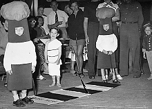
MY PARENTS WERE born in South Africa. They settled in England in about 1947/48. In 1955, when I was three years old, my parents took me on a visit to their native land, possibly to show me off to relatives who lived there.
We travelled to Cape Town by sea. I remember nothing of the voyage, which must have taken about two weeks. Recently, I came across a photograph, which had remained in storage for several decades in my late father’s garage. The picture shows a little boy in a white outfit resembling a Roman toga. He is standing between two children dressed up to resemble, if your imagination is good enough, Belisha beacons such as are found at pedestrian crossings of the zebra variety.
The photograph reminded me of what my mother had told me many years ago. During our voyage to South Africa, we crossed the Equator. My mother told me that to celebrate this event, there was a fancy-dress party for the children on-board. My mother, unlike some of the other parents, had not been aware that this was going to take place. So, she had not packed a costume for me to wear. Ever resourceful and extremely creative (she was a painter and sculptor), Mom used one of the sheets from a bed in our cabin to wrap me up as if I was wearing a toga. Looking at the photograph, it appears that also she fashioned a pair of what look like Roman sandals, using some string. Thus, during my first crossing of the Equator, I was attired in a Roman toga.
Looking at this image, which includes a rug designed to look like a pedestrian crossing, made me think. There I was standing halfway across a zebra crossing whilst our liner crossed from one side of the Equator to the other.