IT IS EASY to miss this small, inscribed stone set low down close to the pavement of Marylebone Lane just south of its intersection with Wigmore Street. The stone is inscribed with the following:
“Conduit belonging to the City of London 1776”
Noticing it for the first time today (14th of November 2024) although I have passed it many times before, I was puzzled by it.
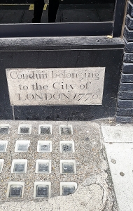
Marylebone Lane runs between Oxford Street and Marylebone High Street. It is far from straight because it follows the course of the now hidden Tyburn River, one of the tributaries of the Thames. Since the middle of the 18th century, this river has run in an underground culvert. Water from this river was once taken from it to supply the City of London with water. As a website (https://coalholesoflondon.wordpress.com/2012/02/21/marylebone-conduit/) informed, the inscribed plaque:
“… reminds us where the water was once piped to the City of London, close by the Lord Mayor’s old Banqueting House, which once stood in fields now occupied by nearby Stratford Place. Alongside this field was a small lane leading to Marylebone – the present day ‘Marylebone Lane’ – where on this corner stood the chief conduit, now marked by this commemorative stone inlaid into the wall and dated 1776 with its City of London claim.”
Had this modest plaque not been placed and preserved, an interesting feature of London’s hydrological history might have been lost for ever. Apart from avoiding pitfalls on London’s not always perfect paving stones, looking where you are walking can often be quite interesting.