DURING THE 1890S, construction of new concrete naval structures commenced at Plymouth naval dockyard. The nearest source of gravel suitable for incorporating in concrete was in Start Bay on the south coast of Devon (just west of Dartmouth). Dredgers, which were able to suck up vast amounts of gravel from the seafloor, were sent to Start Bay. Every day, enormous amounts of gravel were removed from the Bay.
The remains of Hallsands are thr 2 houses closest to the sea
The inhabitants of the tiny fishing village of Hallsands, whose location was between Beesands and Start Point, noticed that as the gravel was being removed, the level of the sea was gradually lowering. This began to become serious because the gravel that was being removed in vast quantities had formerly protected the village (and others nearby) from being washed away by the action of the sea’s waves. When the authorities became aware of the damage being caused, gravel extraction was ended. But this was too late.
A huge storm in 1917 caused most of Hallsands to be washed into the sea, leaving only a couple of houses standing, albeing precariously. Had the gravel not been removed, the damage might have been considerably less, and more of the village might have survived.
Until recently, the precarious remains of Hallsands could be seen from a viewing platform high above the site. However, during the last year or two, further damage has made the path leading to the platform too dangerous to be used, and it has been fenced off.
Neighbouring coastal villages such as Beesands and Tor Cross, have also suffered damage from the sea because of the gravel extraction, but high thick concrete seawalls were constructed and barriers of huge rocks have been placed, and so far the villages’ integrity has been protected.
Old photographs show what Hallsands looked like before it disappeared. They reveal that its buildings resembled those still standing at Beesands. Whereas this village stands on level ground, the buildings in Hallsands used to line a steeply sloping main street that ran downhill to a small fishing harbour.
Although the tragic consequences of gravel extraction were predicted early enough, cessation of the removal of this protective material did not occur until it was far too late to prevent disaster. The villagers who lost their homes and livelihoods had to wait many years before they received any compensation.
Start Bay is a beautiful place to visit. Had our friends Tim and Christine not taken us there, it is quite possible that we would not have become aware of its tragic recent history.
JOHN LINNELL (1792-1882) painted the Kensington gravel pits in about 1811. The picture hangs in London’s Tate Britain These pits lay alongside Bayswater Road and Notting Hill Gate. They provided gravel for building projects in England and as far away as Imperial Russia.
Today, the pits no longer exist. They have been built over, but street names such as St Petersburg Place and Moscow Road commemorate the fortunes made by selling gravel from these pits to Russia.
You can discover more about this and much more about Paddington and Kensington and points further west in my book “BEYOND MARYLEBONE AND MAYFAIR: EXPLORING WEST LONDON” (see https://www.amazon.co.uk/gp/aw/d/B0B7CR679W/
DESPITE THE RAIN, we decided to walk along the path by the River Thames, proceeding upstream from Hammersmith. I had done this before, but never ventured beyond (i.e., upstream) the attractive church of St Nicholas, Chiswick, in whose graveyard you can find the funerary monument to the painter, William Hogarth (1697-1764), whose former home is nearby, and another to the Italian patriot, Ugo Foscolo (1778-1827). After walking along a riverside pathway that passes several recent, moderately attractive, but probably immoderately priced, housing estates, we reached Chiswick Pier at Corney Reach, whose name commemorates the now demolished Corney House, where Queen Elizabeth I was once entertained by the Earl of Bedford, who owned the place (www.chiswickw4.com/default.asp?section=info&page=conhistory29.htm).
Several lovely old houseboats are moored next to the pier. Near the jetty there is a noticeboard explaining the history of each of these vessels. Soon after this, the riverside path enters Dukes Meadow. Up to Barnes Bridge, which is a combined rail and pedestrian crossing over the river, the meadows form a grassy promenade running parallel to the Thames. Beyond the bridge, the meadows widen out and extend to Great Chertsey Road that crosses Chiswick Bridge.
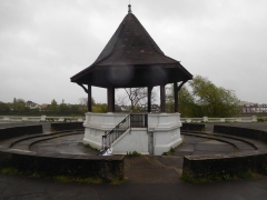
The bandstand at Dukes Meadow
The history of Dukes Meadow is recorded in a detailed essay by Gillian Clegg (https://brentfordandchiswicklhs.org.uk/dukes-meadows-the-threats-to-its-rural-survival/), from which I have extracted most of the following. In the past, the Meadow were low lying farmland and orchards prone to occasional flooding. The land was owned by the Dukes of Devonshire and cultivated by the Jessop family, then later farmed by John Smith of Grove Farm. Incidentally, one of the Dukes, William, the 5th Duke of Devonshire (1748-1811), who had owned nearby Chiswick House in the 18th century. He had both enlarged the house (in 1788) and extended its grounds. At one time, the grounds of Chiswick House must have neighboured the Dukes Meadow. Ms Clegg noted that it was miraculous that the meadows survived as such considering the plans that were proposed for making use of it during the early 20th century.
Two plans were conceived for the ‘development’ of Dukes Meadow. The first was a housing scheme that was to be named ‘Burlingwick’. Clegg wrote:
“On 19 April 1902 The Times newspaper reported that ‘an influential body of capitalists’ had negotiated successfully with the Duke of Devonshire for 330 acres of land for a building plan to be called Burlingwick. The promoter, manager and developer of this scheme was Jonathan Carr, the developer of Bedford Park.”
Had this gone ahead, it would have created housing for up to 400,000 people and 330 acres of green land would have been lost to bricks and mortar. Fortunately, for reasons that are not now too clear the scheme was abandoned in about 1906.
1914 saw the next threat to the Meadows. The Brentford Gas Company planned to cover 80 acres of the Meadow with a huge gasworks. The people of Chiswick and other areas raised strong objections. The London “Times” of 6th February 1914 published its doubts about the scheme, which it said went against all the principles of good town planning, suggesting:
“…that land ripe for building – such as the Chiswick orchard farm – near the heart of the metropolis should be utilized for parks and garden settlement.”
The plan was scrapped, but what the “Times” had alluded to was later realised, but in a then novel way.
In 1923, the local council bought 200 acres of land from the then Duke of Devonshire. The land was to be used as a public recreation area complete with a riverside promenade, a bandstand, and a children’s area with paddling pools. All of this cost the council much money. To recoup some of what they had spent, they made an agreement with the Riverside Sand and Ballast Group. As Ms Clegg explained, the company:
“…was allowed to extract at least five acres every year in exchange for £1,500 an acre.”
The extraction of gravel proceeded from 1924 until 1937 and caused considerable damage to the area. Ms Clegg explained that when the land was finally returned to the council in 1948:
“The gravel pits were filled in, mainly with rubbish brought from inner London, and the area re-landscaped. Dukes Meadows has been described as one of the earliest and most impressive examples of restoration.”
Today, the promenade remains but I saw neither a children’s play area nor paddling pools, which still exist. The bandstand, which stands within a sunken circle lined with steps on which the audience can sit has a hexagonal tiled roof supported by six plain pillars. It is flanked on two sides by spacious shelters, also with tiled roofs. All their roofs are designed so that the angle (or degree) of pitch reduces noticeably about two thirds of the way from the top. Judging by their appearance, I would guess that these structures were built back in the early 1920s. This is confirmed by their appearance in a photograph taken during those years. Also visible in this picture are the unusual, twisted railings, looking like sugar-candy, running alongside the water, and supported by concrete posts with rounded tops. These are still in place today as are their concrete supports which bear simple decorative patterns. Some balustrading can be seen lining the waterfront near the bandstand (see quote below).
Part of the promenade leading towards Barnes Bridge from the Chiswick end of the Meadow is arranged in the form of two long steps. I have no idea why, but maybe they were once used by spectators watching boat races on the river. An article written in 1924 describes the popularity the Meadow with people watching the annual university boat race (http://dmtrust.dukesmeadowspark.com/newriversidepleasaunce.html):
“…in fact so many thousands of people availed themselves of this vantage point last Saturday week at the small admission fee charged by the Council, that over £1,000 net was raised towards the promenade project.”
However, currently a line of bushes obscures sight of the river and the suburb of Barnes across it from these steps. A planning document produced in November 1923 (http://dmtrust.dukesmeadowspark.com/ariversideboulevard.html) sheds a little light on these steps:
“The Scheme, which received the first prize and was submitted by MR A. V. Elliot, of Chiswick, is reproduced on this page. It shows a series of terraces with a plateau of turf, showing seats and rustic shrubberies at intervals, and with a central feature of a bandstand and stone balustrading including a flight of steps and a causeway admitting to the river at all states of the tide.”
We enjoyed our stroll along the Dukes Meadow promenade even though the sky was grey, trees were dripping, and raindrops were falling intermittently. On our way back along the Thames Path to Hammersmith, we stopped at a charming Italian eatery and delicatessen on Chiswick Mall. The place, which is run by Sicilians, is called Mari Deli & Dining, and merits a visit to enjoy a good espresso, at the very least.