A back passage near to London’s Smithfield and Barbican

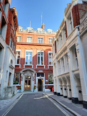
THE CITY OF LONDON has suffered many upheavals including, to mention but a few, the great Fire of London (1666), heavy bombing during WW2, and often overzealous redevelopments after 1945. Despite these major changes, remains of mediaeval London can still be found. One of these is close to the church of St Bartholomew the Great, which escaped being damaged during WW2, and has been standing since 1123. It was founded as part of an Augustinian priory that was dissolved by Henry VIII in 1543. Close to this fascinating church, and running in a straight line from east to west is the narrow East Passage.

This alleyway is about 80 yards long and lined with the rear facades of buildings – mostly not particularly old. Yet, East Passage has been in existence since the dissolution of the priory in the 16th  century (www.ianvisits.co.uk/articles/londons-alleys-east-passage-ec1-36703/). It is a thoroughfare developed on land that had belonged to the priory, and was sold to Sir Richard Rich (1496-1567), who was Lord Chancellor during the short reign of King Edward VI, successor to Henry VIII. East Passage was one of a new series of streets laid out soon after the priory was closed. As the author of the ianvisits.co.uk website pointed out, the group of small straight streets, of which East Passage is one, was one of the earliest planned developments in London (with straight rather than haphazardly arranged, curvy streets), predating the planned development of Covent Garden in the 17th century.

Today, East Passage is about half the length it used to be. Before it was known as East Passage, it was known as ‘Back Court’ or ‘Back Street’. At its west end, there is the rear of a pub called The Old Red Cow. It is one of the longest established pubs near to Smithfield meat market, although the building housing it looks as if it was built in the 19th century. Close to this hostelry, but not on East Passage, there is another pub, The Hand and Shears. Established in 1532, but housed in a more recent building, whose name reminds us that it used to be frequented by cloth merchants. A note in a website (https://darkestlondon.com/tag/old-red-cow/) mentioned that The Hand and Shears:

“… was used as the venue to settle disputes and grievances of people who visited the annual St Bartholomew’s Fair – licences were granted, weights and measures were tested, and fines imposed on fraudulent traders. For many years, the Fair was officially opened from the inn’s doorway by the Lord Mayor – but impatient clothiers would later wait at the pub the night before and declare it open on the stroke of midnight, signalling to gathering crowds that the Fair was officially open by waving a pair of shears in their hands.”

Possibly, I would not have noticed the slender East Passage had we not been sitting in a café nearby. I spotted it through the window of the Pret a Manger on Long Street that runs parallel to East Passage, and felt I had to explore it. As I walked along it, I had not idea that this small back passage had such a long history and would never have existed had Henry VIII not fallen out with the Pope in Rome.

THE ONLY REMAINING VISUAL EVIDENCE OF A CREEK IN WEST LONDON

IN MY BOOK about west London, “Beyond Marylebone and Mayfair: Exploring West London”, I described a stream that used to flow through Hammersmith. It was located where part of Furnivall Gardens now stands today. I wrote:

“… Furnivall Gardens, a pleasant open space created in 1951, and named after a distinguished scholar of English literature and an important pioneer in the sport of rowing, Dr Frederick James Furnivall (1825-1910) … Before WW2, the area of the park was covered with industrial buildings including the Phoenix Lead Mills, which stood east of The Creek, an inlet of the Thames that was filled-in in 1936.

In earlier times, The Creek, which extended as far inland as today’s King Street, was centre of Hammersmith’s flourishing fishing industry. Writing in 1876, James Thorne described The Creek as follows: ‘… a dirty little inlet of the Thames, which is crossed by a wooden footbridge, built originally by Bishop Sherlock in 1751 … the region of squalid tenements bordering the Creek having acquired the cognomen of Little Wapping, probably from its confined and dirty character.’

The Creek, an outlet of the now largely hidden Stamford Brook, is long gone, but there is a storm outlet in the bank of the Thames close to where The Creek emptied into the river. This can be seen from Dove Pier at the western end of the Gardens.”

Today, the 25th of February 2024, we were walking past Furnivall Gardens along the riverside path. It was low tide. A wide, not too clean, beach lined the river. At one point, the beach was interrupted by what looked like the mouth of a small stream. This was lined on both sides with wooden fencing. The stream, which issued from below the riverside walkway ended abruptly in an archway that was filled by a sturdy door or dam. The position of this sluice gate in relation to the nearby Dove pub, Dove Pier, and Furnivall Gardens is correct for what must have once been the mouth of Hammersmith’s erstwhile Creek. I had noticed the archway with the heavy-looking door many times before, but today, because of the low tide, it was the first time that I could clearly the remnants of the mouth of the Creek. I suppose that there is some leakage from the now covered-up Creek that causes the appearance of the mouth of a small stream when the tide is out.

My illustrated book about West London is available as a paperback and a Kindle from:

Tokenhouse Yard

ST MARGARET LOTHBURY CHURCH stands on Lothbury, facing the north side of the Bank of England. It is, so the rector told us, the only one of the churches designed after the Great Fire of London (1666) by Christopher Wren, which did not suffer damage during WW2. It contains some beautifully crafted wooden features including a choir screen originally erected in the Church of All Hallows the Great (demolished 1894) in about 1683. In a side chapel, my wife spotted a gravestone that aroused our interest.

The black grave stone is to commemorate the Barnes family. The name at the top of the carved inscription is “James Barnes Jnr” of Tokenhouse Yard, who died in 1830. Other members of the family, who died later than him are listed below his name. What interested us was James’s address. Tokenhouse Yard, which is just under 100 yards in length, still exists and runs in a northerly direction beginning a few feet away from the west end of St Margaret’s church.

Tokenhouse Yard was laid out by the economist Sir William Petty (1623-1687) during the reign of King Charles I on land which had been occupied by the house and garden of the Earl of Arundel. Petty was, in addition to being an economist, a physician, physicist, philosopher, and one of the first members of the Royal Society. According to an online history of London (www.british-history.ac.uk/old-new-london/vol1/pp513-515) the Yard:


“… derived its name from an old house which was once the office for the delivery of farthing pocketpieces, or tokens, issued for several centuries by many London tradesmen. Copper coinage, with very few exceptions, was unauthorised in England till 1672.”


Daniel Defoe (c1660-1731), who was a child when the Great Plague broke out in London in 1665, later wrote that he remembered terrible sounds and scenes in the then densely populated, and probably somewhat squalid Tokenhouse Yard, many of whose inhabitants were infected. As it was during the worst days of our recent covid19 pandemic, back in 1665 there was nobody out in Tokenhouse Yard. He wrote:


“Passing through Tokenhouse Yard, in Lothbury, of a sudden a casement violently opened just over my head, and a woman gave three frightful screeches, and then cried, ‘Oh! death, death, death!’ in a most inimitable tone, which struck me with horror, and a chilliness in my very blood. There was nobody to be seen in the whole street, neither did any other window open, for people had no curiosity now in any case, nor could anybody help one another. Just in Bell Alley, on the right hand of the passage, there was a more terrible cry than that, though it was not so directed out at the window; but the whole family was in a terrible fright, and I could hear women and children run screaming about the rooms like distracted; when a garret window opened, and somebody from a window on the other side the alley called and asked, ‘What is the matter?’ upon which, from the first window it was answered, ‘Ay, ay, quite dead and cold!’ This person was a merchant, and a deputy-alderman, and very rich.”

Today, few, if any, people live in Tokenhouse Yard. It is now lined with office buildings, some quite elegant. At the north end of the Yard, there is a large decorative terracotta coloured Victorian edifice – number 12, named Token House. This was built for Huth’s Bank in 1872 to the designs of EA Gruning, a German immigrant. The bank was founded by another German – Frederick Huth (1777-1864). Today, the building houses offices.

An archway in the façade of Token House is the entrance to a covered alleyway – effectively a tunnel – that leads to Telegraph Street. This is so-named because it was near the building housing the Electric and International Telegraph Company (founded in 1855). Of interest, if you happen to be in the area, there is a nice coffee house, Ravello, on this street.

The Fire of London destroyed many buildings in 1666. Although these were replaced by newer ones, many of which have been demolished since, the conflagration did not destroy the medieval street layout of pre-Fire London. Thus, today we can enjoy the quaint narrow streets of yesteryear even though many of them, including Tokenhouse Yard and Telegraph Street (formerly the eastern part of ‘Great Bell Alley’) are lined with buildings constructed after Queen Victoria ascended to the Throne. The archaic network of streets in the old City of London add charm to what otherwise would have become a far less interesting urban area.

Before we began carrying personal water supplies

LONG BEFORE LONDONERS began the current fashion of carrying bottle of water wherever they go, the city’s inhabitants had to rely on water sources such as hand-operated street pumps. Although there are still a few functioning public drinking fountains in London, there are no usable pumps to be found. However, a few of them have been kept as historic monuments. One of these is located on the north pavement of Cornhill, a few yards east of the Royal Exchange building.

The pump, which is now kept looking like new – except that it no longer works – was set-up in 1799. On one of its four sides, the manufacturers, Phillips & Hopwood (“Engine Makers”), have included the information that the pump was paid for by the Bank of England, the East India Company, Fire Offices (i.e., insurance companies), and the “bankers and traders of the Ward of Cornhill”. The inscription on this side of the pump also mentions that the it was erected above a well that had been discovered and enlarged.

On another side of the pump, that facing south, there is a brief history of the well. It was first dug before 1282 when Henry Wallis (aka Henry le Walleis; died 1302), thrice Mayor of London, built a “House of Correction” on the spot. This was a prison for “night walkers” and was known as “The Tun”. Stow writing his “Survey of London” in 1598, noted that the prison was built of stone and (preserving Stow’s spelling) we learn:
“In the yeare 1298. certaine principall Citizens of London, brake vp this prison called the Tunne, and tooke out certain prisoners for the which they were sharply punished by long imprisonment, & great fines, as in another place I haue shewed.
In the yeare 1401. this prison house called the Tunne was made a Cesterne for sweete water conueyed by pipes of Leade frõ the towne of Tyborne, and was from thence forth called the conduite vpon Cornhill: Conduite vpõ Cornhill.Then was the wall planked ouer, and a strong prison made of Timber, called a Cage, with a payre of stockes set vpon it, on the top of which Cage was placed a Pillory for the punishment of Bakers offending in the Assise of Breade: for Millers stealeing of Corne at the Mill: and for baudes Cage, stockes and pillorie vpon Cornhill.and scolds &c.”

By the time the pump was set-up, the prison had long since gone (? demolished). How and why the well was rediscovered, I cannot say, but it was, and its water became accessible by using the pump. The top of the pump serves as an advertisement. At the top of each of the four sides of the pump, there are symbols, which people would have recognised as being the trademarks of four insurance companies in existence at the time that it was established. Back in the 18th and early 19th centuries, firefighting services were provided by the insurance companies. The trademarks of insurance companies were placed on buildings so that firefighters of each insurance company could recognise which houses had paid for policies that made them eligible to be saved by the firemen.

Today, firefighting is no longer provided by insurance companies, and water is no longer available from public pumps. So, it is not surprising to see many people wandering around London with their own supplies of drinking water – in plastic bottles and other containers. What does surprise me is that when I was younger, in the 1960s and 1970s, one hardly ever saw people carrying their own drinking water. Now, it is quite common to see people sipping from their personal water carriers. Have people become thirstier recently, or what is it that makes them feel that they should never be without a portable supply of potable water?

Beyond London’s West End: the story of west London

BEFORE THE YEAR 1800, the West End was truly the western end of London. West of Mayfair and Marylebone, there was countryside: woods, fields, private parks, farms, stately homes, villages, and highwaymen. After the beginning of the 19th century, the countryside began to disappear as villages grew and coalesced and the city of London expanded relentlessly westward. What had been rural Middlesex gradually became the west London we know today.  My new book, illustrated with photographs and maps, explores the past, present, and future of many places, which became absorbed into what is now west London: that is London west of Park Lane and the section of Edgware Road south of Kilburn. Some of the places described will be familiar to many people (e.g., Paddington, Kensington, Fulham, and Chelsea). Other locations will be less known by most people (e.g., Acton, Walham Green, Crane Park, Harmondsworth, and Hayes). Many people have seen the places included in my book when they have looked out of the windows of aircraft descending towards the runways at Heathrow, and many of them will have passed some of these places as they travel from Heathrow to their homes or hotels. My book invites people to begin exploring west London – a part of the metropolis less often on tourists’ itineraries than other areas. “Beyond Marylebone and Mayfair: Exploring West London” is aimed at both the keen walker (or cyclist) and the armchair traveller.  

Beyond Marylebone and Mayfair: Exploring West London is available as a paperback from Amazon here:

https://www.amazon.co.uk/BEYOND-MARYLEBONE-MAYFAIR-EXPLORING-LONDON/dp/B0B7CR679W/: