I AM ALWAYS WARY about visiting the ‘must-see’ places partly because I hate queuing and do not particularly enjoy crowds. Also, one of the few flaws in my personality is that I love visiting places that are off the beaten track taken by most visitors to a town or city. That said, I visited one of Istanbul’s most popular tourist attractions today – The Grand Bazaar – on my way to places less often seen by tourists.
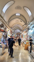
The Grand Bazaar (Kapali Çarşi = ‘covered bazaar’) covers a huge area, and is like a city within a city. It has 62 covered streets and about 4000 shops. It’s construction commenced in about 1455/56 – a very few years after the Ottoman conquest of Constantinople/Istanbul. Much of its construction occurred during the second half of the 15th century, and it was largely completed by the beginning of the 17th century.
Many things impressed me about the Bazaar. It is very clean. The numerous shops are mainly tidy. Until we entered the place, I had not realised that it is built on a hillside. Many of its gently curving streets (or wide corridors) are far from level – they slope gently. The beautiful curved ceilings, supported by numerous arches, are wonderfully decorated with painted Ottoman motifs and patterns – tasteful not garish. Despite the presence of many people – tourists and locals – the bazaar did not feel crowded. Because of the great width of the streets, the bazaar did not have the bustling feeling that many large bazaars in India have.
All in all, despite my initial reservations about entering such a ‘mustn’t miss’ attraction, I greatly enjoyed visiting the Grand Bazaar, and am very pleased I did.
ONE AFTERNOON IN April (2024), out of curiosity we travelled by bus number 46 from Smithfield to Paddington station instead of taking the much faster Underground train route. As we proceeded along the whole route of the number 46 bus, we realised that it links several places of interest to both Londoners and visitors to the city.
The 46 starts within easy walking distance of the BARBICAN CENTRE, SMITHFIELD MARKET, ST BARTHOLOMEW THE GREAT, and THE LONDON MUSEUM. Also, its first stop outside ST BARTHOLOMEWS HOSPITAL is not far from ST PAULS CATHEDRAL.
When the bus gets moving, you will soon pass the ornate Victorian HOLBORN VIADUCT and HATTON GARDEN – famed for its diamond merchants. Next, you will see the Victorian gothic PRUDENTIAL BUILDING and before turning on to Grays Inn Road, you will see a row of half-timbered houses – some of the only PRE-FIRE OF LONDON survivors. Much of the west side of Greys Inn Road is lined with the buildings of GREYS INN – one of London’s four historic Inns of Court.
KINGS CROSS STATION and the magnificent Victorian gothic ST PANCRAS STATION are the next things to look out for. You could leave the bus here to explore the new developments around Kings Cross including COAL DROP YARD and KINGS PLACE hall and events centre. If you remain on the bus, you will head north past the ROYAL VETERINARY COLLEGE to the not over attractive KENTISH TOWN. At CAMDEN ROAD STATION, you will not be far from the REGENTS CANAL and the popular CAMDEN MARKET.
Heading northwards, the 46 reaches Fleet Road in south Hampstead, which is a short walk from the famous Modernist ISOKON BUILDING in Lawn Road. You could disembark at South End Green and visit Mirko to enjoy refreshments in his small MATCHBOX CAFÉ. HAMPSTEAD HEATH is a few minutes’ walk away. If you remain on the bus, you will pass the ROYAL FREE HOSPITAL and next to it, the Victorian gothic ST STEPHENS CHURCH designed by SS Teulon.
The bus then heads up Rosslyn Hill into the heart of historic HAMPSTEAD, where there is plenty for the visitor to explore. Then, the 46 descends the steep Fitzjohns Avenue to Swiss Cottage. Just before it reaches there, look out for the statue of SIGMUND FREUD at the southern end of the Tavistock Institute. The house where Freud lived, now THE FREUD MUSEUM, is close by.
After passing St Johns Wood Station with its several scraggly palm trees, the bus winds its way through streets near Maida Vale until it reaches Warwick Avenue Underground station. Descend here to walk to the REGENTS CANAL near to where it enters the scenic LITTLE VENICE.
Soon, after passing beneath the elevated WESTWAY, the 46 heads for its last stop, which is on a bridge from which you can get a good view of the wonderful glass and ironwork roof of PADDINGTON STATION – a masterpiece of Victorian engineering. From Paddington, there are a few bus routes that will allow you to continue your London sightseeing.
ON THE DAY BEFORE the second English ‘lockdown’ commenced in early November (2020), we drove to Abingdon Piggott to enjoy one more excellent luncheon at the Pig and Abbott pub. On this, our fourth visit in the same number of months, I enjoyed one of the best fish pies I have ever tasted. On our way to lunch and to satisfy our love of sightseeing, we visited Buntingford, a small town in the east of Hertfordshire.
As the ‘ford’ part of the town’s name suggests, Buntingford is on a river, the River Rib, which is a tributary of the River Lea. Also, the town lies on the course of the Roman road known as Ermine Street, which linked London with Lincoln. For many centuries, Buntingford, which is located just west of the Greenwich (or Prime) Meridian, was a staging post on the main road from London to Cambridge, the current A10. The town contains many buildings that were once coaching inns. Of these, only one or two still operate as pubs. Since this main road was diverted around Buntingford via a bypass constructed in the mid-1980s, the town, filled with historic buildings, has become a pleasant backwater.
The town’s name is most likely derived from ‘Bunta’, which was the name of an Anglo-Saxon tribe or its chieftain. A local historian, one Frank Bunting, writes (www.hertsmemories.org.uk/content/herts-history/towns-and-villages/buntingford/origin_of_buntingford_name) that there was once a village called ‘Bunting’, which was a few miles north of the present Buntingford. It is, he claims, marked on a map drawn in 1732 by Herman Moll (c1674-1732), which does not mark Buntingford, which was probably then too small to add to the map. Now, according to the historian, Bunting has disappeared and Buntingford is a town of some size. I have looked at an on-line copy of Moll’s map of Hertfordshire (https://www.archiuk.com/cgi-bin/slideshow_loop.pl?gallery_subject=herman_moll&filename2show=hertfordshire-old-map-1724-herman-moll.jpg&launchpage=old-map-index-page) and found that it marks ‘Bunting’ close alongside ‘ford’, the two words being separated by Moll’s simple plan of the town. It appears that Buntingford was significant enough to appear on Moll’s map and that the place called ‘Bunting’ probably never existed in this area. A document prepared by or for the Knights Templars in 1185 mentions the town as ‘Buntas Ford’.
Most of the older part of Buntingford lies alongside the long straight road, the former Ermine Street. It is here that you can see the former coaching inns, each with an archway leading to the courtyards behind them. There are also several other picturesque edifices dating back to the 18th century and earlier. At the south end of the High Street, there is a Church of England church, St Peters, which looks Victorian, but it was originally constructed in about 1615. It has undergone so much modification that its early origin is difficult to discern. Just north of this is the Manor House, a fine 18th century building, which now houses the offices of the Town Council. Next to this on the side of the road there is a wooden enclosure containing a hand operated water pump encased in timber. This was erected to commemorate the Diamond Jubilee of Queen Victoria’s reign in 1897. The Black Bull pub opposite the Town Council is one of the few former coaching inns still serving as a hostelry.
Church Street that leads east from the Ermine Street winds downhill to the River Rib. It passes an attractive gothic revival cottage called ‘Fancy Hall’ (built 1825) and then a quaint old pub, the Fox and Duck (first licensed in 1711), which does not look like it was formerly a coaching inn. The River Rib flows just below the pub and can be crossed either by a bridge or a ford, which looks recently constructed. The ford after which the town got its name was where the Rib crossed Ermine Street.
Next, Church Road continues uphill on the other side of the river but with the name, The Causeway. It winds steeply uphill first passing a long brick wall, the boundary of a private property called Little Court, which I was unable to enter. This building was constructed in the early 19th century with bricks from an earlier building on the site that was built in 1598 and demolished in 1819 (https://historicengland.org.uk/listing/the-list/list-entry/1174663). The road continued seemingly endlessly up hill and into the countryside before ending at the isolated, flint walled Layston Church. This is St Bartholomew whose construction began in the 13th century if not before. The roof of its nave is of very recent construction (21st century) with a row of skylights below the roof tiles. The church is now used as a private dwelling. Known in the Domesday Book as ‘Ichetone’, the parish of Layston contained the town of Buntingford. Therefore, the now deconsecrated church of St Bartholomew used to be Buntingford’s parish church, a role now assumed by St Peter in the town.
In common with Washington DC, Buntingford has its own White House. Built in the 18th century, this is not the home of presidents, but probably served as a private residence. Opposite it, and high above the pavement and above a passageway leading to a car park, there is a small, picturesque clock with its own gabled roof. It is an example of a single-handed turret clock. It was already in existence in 1618, when local citizens paid for various alterations and repairs. The clock, which might have been first placed there in 1558, has undergone numerous modifications and improvements over the centuries but what we see does not look remarkably different to how it was originally. It contained a bell that was replaced in 1742 by the present one, which is sounded on auspicious and sad occasions including on the day of the funeral of Wellington in 1852.
I hope that I have written enough to persuade you to spend an hour or two in Buntingford, a town that is often bypassed at speed by motorists on the A10. Once again, we have found much of interest in a place in England that hardly gets a mention in guidebooks yet is full of beautiful historical sights. By the way, if you are in need of a coffee whilst in Buntingford, you would do well to visit The Buntingford Coffee Shop, which is almost beneath the ancient Town Clock.


