The River Thames is tidal where it flows through the heart of London. At low tide, sandy beaches appear alongside the river’s banks. What is often beneath the water is revealed for a few hours. People, known as ‘mudlarks. wander along the sandy beaches looking for objects and fragments that have been thrown into, or lost in, the water over the many centuries that the city has been in existence. I have never attempted mudlarking, but many people enjoy searching for lost treasures.
THE ISLAND OF MERSEA is connected to the mainland of Essex by a causeway, which was originally constructed before the medieval era. It is the only way that vehicles, motorised or otherwise, can travel between Mersea and the rest of Essex.
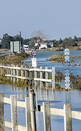
Twice a day, the tide rises. When it does, not only do the mudflats close to the island become submerged beneath the sea but also the causeway.
The flooded causeway
After visiting East Mersey, we drove to the causeway and had to stop in a long queue of traffic. It was high tide, and the water had not only covered the causeway but also about 200 yards of the roadway approaching it. It was interesting to see how even in the 21st century, a simple thing such as high tide can bring life to a standstill.
IN MY BOOK about west London, “Beyond Marylebone and Mayfair: Exploring West London”, I described a stream that used to flow through Hammersmith. It was located where part of Furnivall Gardens now stands today. I wrote:
“… Furnivall Gardens, a pleasant open space created in 1951, and named after a distinguished scholar of English literature and an important pioneer in the sport of rowing, Dr Frederick James Furnivall (1825-1910) … Before WW2, the area of the park was covered with industrial buildings including the Phoenix Lead Mills, which stood east of The Creek, an inlet of the Thames that was filled-in in 1936.
In earlier times, The Creek, which extended as far inland as today’s King Street, was centre of Hammersmith’s flourishing fishing industry. Writing in 1876, James Thorne described The Creek as follows: ‘… a dirty little inlet of the Thames, which is crossed by a wooden footbridge, built originally by Bishop Sherlock in 1751 … the region of squalid tenements bordering the Creek having acquired the cognomen of Little Wapping, probably from its confined and dirty character.’
The Creek, an outlet of the now largely hidden Stamford Brook, is long gone, but there is a storm outlet in the bank of the Thames close to where The Creek emptied into the river. This can be seen from Dove Pier at the western end of the Gardens.”
Today, the 25th of February 2024, we were walking past Furnivall Gardens along the riverside path. It was low tide. A wide, not too clean, beach lined the river. At one point, the beach was interrupted by what looked like the mouth of a small stream. This was lined on both sides with wooden fencing. The stream, which issued from below the riverside walkway ended abruptly in an archway that was filled by a sturdy door or dam. The position of this sluice gate in relation to the nearby Dove pub, Dove Pier, and Furnivall Gardens is correct for what must have once been the mouth of Hammersmith’s erstwhile Creek. I had noticed the archway with the heavy-looking door many times before, but today, because of the low tide, it was the first time that I could clearly the remnants of the mouth of the Creek. I suppose that there is some leakage from the now covered-up Creek that causes the appearance of the mouth of a small stream when the tide is out.
My illustrated book about West London is available as a paperback and a Kindle from: